1 mile (by boat) E of Delaware City (302) 834-7941
Managed by: Delaware State Parks
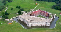
Situated on Pea Patch Island, a 10-minute passenger ferry ride from Delaware City, Fort Delaware is a majestic Civil War-era masonry fort. The island's undeveloped northern end boasts the largest mixed rookery of herons and egrets on the East Coast of the U.S. Prospective visitors should note that there is no public access to the immediate nesting area, but an observation platform approximately 300 yards from the south edge of the colony allows good views of the comings and goings of the adult birds. Once you have landed on the island, it is about 0.3 mile walk to the fort, and another 0.5 mile northwest from there to the observation point. A spotting scope is helpful, if you have one.
Directions to the Fort Delaware State Park ferry dock:
(39°34'23.60"N 75°34'50.56"W) From the intersection of Route 9 and Clinton Street in Delaware City, go east on Clinton Street 0.5 mile to its end at the river. The ferry dock and park office are on the right (S). The east end of Clinton Street is also a good vantage point for viewing the birds around the herony; though the distance is substantial, one gets a sense of the true size of the colony. As of this writing, ferry service is available on weekends from late April through late September. From mid-June through Labor Day, the park is open Wednesday through Sunday. Please contact the park for updated information when planning a visit.
Other Birding Sites in the Delaware River Coast Region:
- Fort duPont State Park
- Fort Delaware State Park
- Thousand Acre Marsh