 Directions to the Visitor Center
:
(39°15'34.92"N 75°28'23.85"W) From Route 1 near Smyrna, take exit 114 (Smyrna-South exit). At the end of the ramp turn right (N) at the traffic light onto Route 13 North. Turn right (E) at the next light onto Road 12 (Smyrna-Leipsic Road). This road merges with Route 9 South in just under 5 miles. Immediately after joining Route 9, turn left (E) onto Whitehall Neck Road which ends in 2.5 miles at the refuge headquarters area.
Directions for the Auto Tour (mileages are from visitor center):
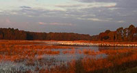
From the visitor center, turn left (E) out of the parking lot. At the "T" intersection (0.1 mile), follow the tour loop to the right around Raymond Pool, passing the observation tower and the boardwalk trail before paralleling the pool's edge. The road then makes a "T," (1.6 miles). A left here will return you to the visitor center; a right parallels the northeast face of at the eastern extent of Shearness Pool. (1.7 - 3.0 miles). Beyond Shearness, turn right (E) to circle Bear Swamp Pool (3.3 - 5.4 miles). At 5.4 miles. the Bear Swamp
Loop rejoins the road from Shearness. Turn right (W), then left (S) at 5.5 miles, to reach Finis Pool (6.4 miles). A direct return from Finis to the visitor center takes another 3.6 miles, for a total circuit of about 9 miles.
Other Birding Sites in the Delaware Bay Coast Region:
- Woodland Beach Wildlife Area
- Bombay Hook National Wildlife Refuge
- Little Creek Wildlife Area
- Ted Harvey Cons. Area - Logan Lane Tract
- Milford Neck
- Slaughter Beach
- Prime Hook National Wildlife Refuge